http://www.chemistrymag.org/cji/2008/109043pe.htm |
Sep.
1, 2008 Vol.10 No.9 P.43 Copyright |
The Speciation of phosphorus in sediments of the Yellow River and inflow sands in western Inner Mongolia
Li Ying1,
Yang Xiaohong2, Yang Hongwei3, Zhang Yi3, Jiao Xiaobao3,
Guo Boshu3
(1.Chemistry Dept of Jining Normal College , Wulanchabu,Inner Mongolia 012000. 2.
College of Chemistry and Chemical Engineering, Inner Mongolia University,Huhhot
010021. 3. Chemistry and Enviroment Science College of Inner Mongolia Normal
University, Huhhot 010022, China )
Supported by the Natural Science Foundation (20467002)
Abstract Phosphorus is often the
limiting nutrient for algal growth and may limit marine productivity. At present, most
studies are focused on dissolved phosphorus concentrations and distribution in our
country, and little is known about the suspended particulate phosphorus and the phosphorus
dynamics. The phosphorus in sea is partially from sands and river inputs. The phosphorus
conveyer belt comprised of the deserts in western Inner Mongolia, the sandstorm, the
Yellow River and its estuary, the Yellow sea and the north maritime space in China is part
of the global phosphorus cycle. In this paper, an improved Ruttenberg analytical method
was used to study the speciation of phosphorus in surface sediments from the mainstream of
the Yellow River and the speciation in its main inflow sands. The bio-available species of
phosphorus in the sands and the sediments are calculated. Furthermore, the possible
impacts on the river and marine ecosystem are also discussed.
Keywords Phosphorus; Speciation; Sand particle; River sediment; Western Inner
Mongolia
1. INTRODUCTION
The primary productivity of most oceans in the world is controlled by nitrate and
ferrite. However the Eastern Mediterranean is limited by phosphate[1], which
remains a mystery and research focus internationally. The most popular hypothesis in the
past decade that sands in Saharan desert absorbed a great deal of phosphorus in East
Mediterranean[2] was not proven by experiments.
Redfield[3] believed that phytoplankton in the ocean
absorbed nutrient with the N:P:Si proportion of 16:1:16, lower or higher than which would
result in nitrate or phosphorus limitation. Recent years has witnessed obvious phosphorus
limitation over phytoplankton around the offshore area of China. In September 2004 Meng
Chunxia[4] conducted an intensified research in the area of Yellow River mouth
and nearby sea waters. Results showed that the ratio of N to P in sea water around Yellow
River mouth was 111, with the surface water ratio at 150 and bottom water at 53. Both were
much higher than the figure given by Redfield. The ratio of N to P in the water of Yellow
River mouth was 684,higher than the average ratio of
503 found along the same area in 1980s.
This increase could result from the change of import source of nitrogen
and phosphorus in the Yellow River.
In the northern part of China inorganic particles came mainly through
three channels, which were sand and dust from Hei-feng-kou area, Wulanbuhe Desert and
Kubuqi Desert particles and soil of Loess Plateau. The latter two were the major
contributors of Yellow River sediments.
The mysterious Hei-feng-kou region locates in the northern part of
Badanjilin Desert. Because of the differences of air pressures, airflows and temperatures
between Siberia- Mongolia belt and the Yellow Sea, the sand and dust stretches over a
dozen kilometers and floats from the west to the east. It passes Hohhot, Loess Plateau,
Beijing, Huabei Plain and runs all the way down to the Bohai Sea and Huanghai Sea. Because
the sand and dust flow in Ejinaqi county of Inner Mongolia looks like a black curtain
hanging from the blue sky, this region Hei-feng-kou, literally meaning Black wind mouth,
is named after the magnificent view. While sand storm brings great harm to nature and
human being, it also carries a large amount phosphorus into rivers and oceans.
Being the 8th biggest desert in China, Wulanbuhe annually
contributes 28.63 million tons of sand to the Yellow River. Kubuqi Desert, the 7th
in the country, sees 23.68 million tons of sand run into the Yellow river through ten
major irrigation works in every torrential rain season. Thus the two deserts become main
contributors of sediments in Yellow River in Inner Mongolia[5]
The Yellow River is the 2nd longest river in China and the
top river in terms silt discharge and silt concentration in the world. Phosphorus flux
from Yellow River plays a significant role in maintaining the eco-balance of the Bohai Sea
and the Pacific.
This study aims at analyzing phosphorus specification of sands in
Yellow River and identifying distribution features of phosphorus speciation of surface
sediments from the river’s mainstream, the source of
phosphorus as well phosphorus importation to the sea.
2.EXPERIMENTAL SECTION
2.1 Sampling
The locations of dust sample, desert sample and Yellow River sediments sample are shown in
Figure One. Sampling is carried out in accordance to documentation of 1999 Herut.B[6]
et al. Samples are kept in frozen conditions and classified into four grades, that is,
0.150mm,0.105mm,0.063mm and natural size.
Sample water from the Yellow River is kept in cool conditions with NaN3
bacteriostatic agent added 1g/l. The timing of sampling is April and May 2006.
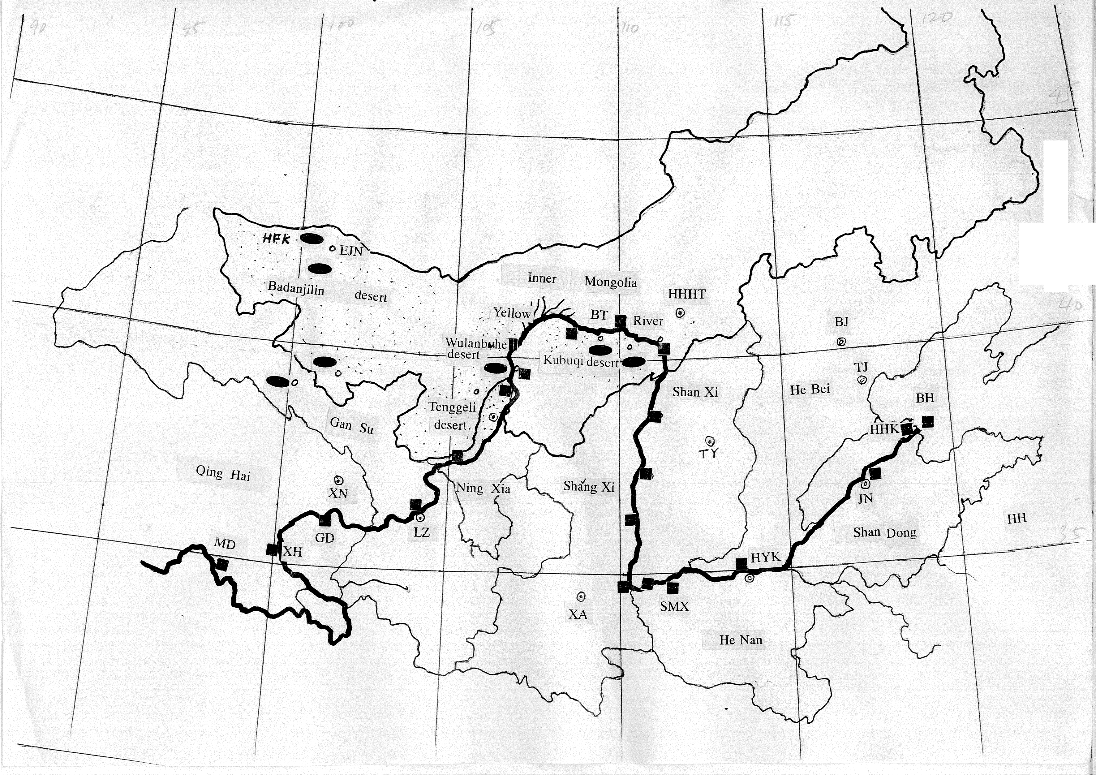
Figure 1 Location of the samples
Notice :![]() represents sampling locations of sands and
represents sampling locations of sands and ![]() represents sampling locations of
surface sediments in the mainstream of Yellow River.
represents sampling locations of
surface sediments in the mainstream of Yellow River.
2.2 Experiment
All solid samples were analyzed for Si, Al, Fe, Mn, Mg, Ca, Na and K content by XRF.
Typical results were shown in Table 1.
Table 1 Chemical analysis of all sands in deserts
Site |
SiO2 |
Al2O3 |
TFe |
CaO |
MgO |
K2O |
N2O |
P2O5 |
Linze |
78.89 |
7.66 |
1.82 |
2.37 |
1.70 |
1.70 |
1.68 |
0.11 |
Heifengkou |
61.64 |
11.07 |
2.49 |
3.38 |
3.38 |
2.29 |
3.28 |
0.12 |
South Badanjilin |
84.10 |
8.04 |
0.44 |
0.30 |
0.30 |
2.21 |
2.34 |
0.05 |
The SEDEX method was used for the measurement of particulate P
speciation in the dust and sediment. The extraction procedure consists of five sequential
leaching steps which extract the following: (1) exchangeable and loosely bound P (Pex),
(2) iron-bound P (PFe), (3) authigenic and biogenic apatite and calcium
carbonate bound P (Paut), (4) detrital apatite and any other remaining
inorganic P phases (Pdet), and (5) organic P (Porg). Details of the
extraction were given elsewhere[7] .
In most solutions
phosphate was analyzed spectrophotometrically by the standard phosphomolybdatre blue
method. This method could not however be used directly for the CDB solutions, since the
extraction interferes with the molybdate blue reagent. These solutions were first reacted
with a 1% FeCl3 solution, extracted into isobutanol and then analyzed by
spectrophotometer[8].
Table 2 SEDEX Procedure. The extraction was carried out sequentially, with 25ml of solution and 250mg of sample being used.
Phosphorus |
Extraction |
Pex |
1mol/LMgCl2 (pH=8)2×2h, water washes |
PFe |
22.5ml0.3mol/L+1mol/LNaHCO3(pH=7.6)+0.564g Na2S2O4
(CDB solution),1mol/L
MgCl2(pH =8)2h, water wash,2h 22.5ml of 0.3mol/LNa3―Citrate+1mol/LNaHCO3 (pH=7.6)+0.564g Na- dithionite (CDB solution), 1mol/LMgCl2 (pH =8), 2h, water wash, 2h |
Paut |
1mol/L NaAC―HAC buffer
solution (pH =4),6h |
Pdet |
1mol/LHCl, 16h |
Porg |
550℃burn ,2h. 1mol/LHCl,16h. |
3.RESULTS
AND DISCUSSON
3.1 Sands
Table 3 Content of phosphate in sands at monitoring sites
Site |
Size |
Pex |
PFe |
Paut |
Pdet |
Porg |
TP |
mg/g |
mg/g | mg/g | mg/g | mg/g | mg/g | ||
Hei-feng-kou |
natural size 130-150 mm<63 mm |
25.93 9.78 31.17 |
18.70 17.16 15.71 |
823.75 774.89 1762.55 |
8.12 11.53 8.53 |
84.99 90.22 68.22 |
961.49 913.59 1888.18 |
Kubuqi- tuo county |
natural size 130-150 mm<63 mm |
10.86 6.66 5.85 |
60.02 67.19 68.66 |
573.78 487.64 298.12 |
125.11 87.34 375.54 |
9.51 9.20 20.83 |
779.28 658.03 769.00 |
Kubuqi- Xiangshawan |
natural size 130-150 mm<63 mm |
29.06 28.88 17.22 |
69.36 158.12 77.04 |
170.22 202.13 378.11 |
110.76 68.33 474.72 |
10.98 17.09 32.25 |
390.38 474.55 970.45 |
Wulanbuhe- dengkou |
natural size 130-150 mm<63 mm |
17.22 12.73 10.87 |
52.13 31.23 6.38 |
164.15 334.95 256.33 |
139.89 102.20 437.96 |
20.83 10.48 21.16 |
394.22 491.59 732.60 |
Most sands
over 0.1mm will settle onto the river bed and that small than 0.1mm will deposit on the
bank or float over the water. TP content of sand in western Inner Mongolia desert ranks
between 390.38-1888.18mg/g.
Heifengkou, Tuo county in Kubuqi desert, Xiangshawan of Kubuqi desert and Dengkou of
Wulanbuhe desert run from high to low in terms of phosphorus content. And the smaller the
size of sand, the higher is the phosphorus content. Heifengkou region used to be a lake
area with high productivity. It is now part of Ejina oasis and locates next to Mongolia
grasslands. That is why the sand phosphorus in this region ranks first. Whereas with the
situation of Tuo County in Kubuqi desert, the soil along seasonal rivers is fertile and
sands in the region is relatively small. When sands containing phosphorus settle down in
the Yellow Rivea, Pex will be released and phosphorus level in the upper water
gets increased. Pex refers to phosphorus absorbed by oxide, hydroxide and clay
minerals in the sediments. With the combined effects of T, pH, water and bioprocess, Pex
will be released to join in re-circulation. According to calculation, each year
Wulanbuhe desert will send 11,000 tons of TP to the Yellow River, out of which 4920 ton is
Pex. And Each year Kubuqi desert will send 9,200 tons of TP to the Yellow
River, out of which 688 ton is Pex.. Pex is the weakest phosphorus
in combinability. Pex released in the water is either absorbed by aquatic
plants and animals or transported to the ocean to promote primary productivity of sea
waters. It is very convenient for the two deserts to contribute sand into the Yellow
River, with Wulanbuhe being the first contributor of sediment TP and Kubuqi Xiangshawan
being the first of dissolvable phosphorus. The content of bio-available phosphorus like PFe、Porg are also very high in the two deserts. These are
released in the process of oxidation-reduction, organics mineralization and decomposition
and therefore become the phosphorus source of sediment in rivers and oceans.
Table 3 shows that Pau is the main specification of sand in
western Inner Mongolia, and which accounts for 41.3 to 73.6% of the TP. Pdet from
igneous rock and metamorphic rock is also very high, taking a share of 16-45% of TP. In
Kubuqi desert, Paut, Pde, PFe Pex and Porg
run from high to low. In Wulanbuhe desert it takes an order of Paut, Pdet,
PFe , Porg, Pex from high to low. The content of
phosphorus is relevant with the size of sand, with Pdet and Paut being
dominant for 130-150mm and <63mm sand and PFe being rich in bigger sands. This is
because PFe is likely to co-precipitate with ferric oxide like szomolnokit,
lepidocrocite and goethite, while the content of ferrous free oxygen is high in 130―150μm sand. Relatively more
light, heat, water and efflorescence effect results in higher iron oxidation and PFe,
which in turn explains high content of phosphorus in Kubiqi desert.
The fact that Pdet is over 130-150mm in<63mm sand demonstrates Pdet
high in the sands of western Inner Mongolia. The content of Porg displays the
same characteristics as the content distribution of sand organism, which means that <63mm sand is higher than
130-150mm sand.
That is because Por forms a part of organics. And the smaller is the size, the
wider is the specific area and the easier for organics to absorb.
3.2 Heifengkou Sand
Heifengkou is today's Xijuyanhai or Shungenuoer region. A very dry piece of land now,
it locates in the northern part of Badanjilin desert and adjacent to the People's Republic
of Mongolia.
In 2005 Zhang Kai's[9] research showed that 48.6% of dust
occurred in the 12 sand storms in 2000 was originated from western Inner Mongolia desert,
38.0% of dust occurred in the 18 sand storms in 2001 was originated from western Inner
Mongolia desert, and 25.0% in the 12 sand storms in 2002 was originated from the region.
The research also found that the dust floated from western Inner Mongolia desert and loess
plateau to the vast North China plain, Bohai Sea, Yellow Sea, sea of Japan and the
Pacific. The western desert of Inner Mongolia has become one of the four high-frequency
sand storm region. It is a very important component of central Asia dust area and the
source of middle-route sand storm in the country.
Table 3 shows TP in Heifengkou can be as high as 961.49μg/g, of which sands <63μm
being the highest and reaching 1888.18mg/g,the next
being natural size and last being sand of 130-150mm. Sands over 63μm is not
likely to transport with wind. The majority part of sands, or 99.4%, in Heifengkou area
falls in this category and indicates the potential expansion of deserts. The sands smaller
than 63μm will become flying dust and run through the
northern part of China to coastal regions. It is a source of phosphorus in the nearby sea
water and the Pacific. Thus Heifengkou forms the transport mechanism of phosphorus to the
ocean. Study conducted by Zhang Xiaoye[10] in 2001 showed that in northwestern
part of China 20% of dust containing phosphorus settled down on the loess plateau and 50%
was transported to the faraway Pacific. In 1950s a belt of quartz-containing dust sediment
were found in northern Pacific. The latitude, between 30°and 40°N, is almost the same as
loess plateau's distribution[11].
Pex and Porg are the dominant content of
bio-available phosphorus in Heifengkou sands, with Pex hits 19.78mg/g to 31.17mg/g and Porg hits
68.22mg/g
to 90.22mg/g. Both are higher than those in Wulanbuhe desert and Kubuqi
desert. When Heifengkou sands carrying phosphorus falls in the ocean, part of DIP and DOP
will resolve in the water. Since DIP and DOP concentration is very low in the sea water,
the sands from Heifengkou becomes the source of phosphorus. Research conducted by Dong
Yemaixing[12] in 1996 showed that phosphorous in the water was almost all
absorbed by species and became bioclast, which would go further deep into the sea and be
resolved into the sea by micro-organism. The part that is not dissolved will enter the
deep-sea sediments. Phosphorus in surface water will participate in the species cycle,
which is obviously a bioactive process.
The sand storm is a key link in nature cycle and global
biogeochemistry. It even plays an important role in protecting environment like purify
air, reducing acid rain, promoting growth rate of marine biology and lower the pace of
global warming. Sands is rich in Fe and P, which sea waters lacks.
3.3 Surface Sediment of the Yellow River
Dust flux and silt density of the Yellow River ranks the top of the world. According
to statistics from 1950 to 1999, the annual average flux was 8.68×10⁸t/a,the average meridional flow is 343.8×10⁸m3/a,
accounting for 78% of total amount in Bohai sea[13].
Table 4 The mineral composition of surface sediments in the mainstream La
Ma Wan of the Yellow River(%)
Composition simples |
chlorite |
illite |
a -quartz |
orthoclase |
plagioclase |
calcareous |
dolomite |
hornblende |
1 <105 mm105-125 mm125-200 mm |
10 10 8 |
15 20 15 |
33 34 35 |
10 13 15 |
18 13 15 |
2 2 4 |
2 1 1 |
10 4 5 |
2 <105 mm105-125 mm125-200 mm |
10 10 10 |
15 20 10 |
35 35 35 |
10 10 10 |
20 15 20 |
4 4 9 |
1 1 1 |
5 5 5 |
3 <105 mm105-125 mm |
6 5 |
10 8 |
35 45 |
10 15 |
20 20 |
5 4 |
2 2 |
10 1 |
Because Wulanbuhe and
Kubuqi deserts are the main source of Yellow River sediments in Inner Mongolia, 35% of the
sediments is α- quartz,10-15% is clay minerals and 30% is plagioclase and
orthoclase combined. This is a distinctive feature of surface sediments in the Yellow
River.
Table 5 displays the
chemical and physical characteristics of water in different parts of the Yellow River’s mainstream. It shows high pH, high DO and high Eh value, which in
turn means Fe(III) forms the dominant part in the Fe of PFe. After the section
of Wuhai and Linhe, the Yellow River enters the Hetao area featuring broad irrigation. The
degree of mineralization and electric conductivity get increased. The content of organic
matter is relevant with the Porg content.
Table 5 The chemical and physical characteristics of water in the Yellow River
site Item |
SZS |
WH |
LH |
WLT |
BT |
LMW |
TG |
SMX |
HYK |
JN |
HHK |
pH |
8.34 |
8.49 |
8.51 |
8.51 |
8.45 |
8.57 |
8.41 |
8.38 |
8.41 |
8.41 |
8.40 |
DO(mg/L) |
5.45 |
5.54 |
5.58 |
5.62 |
5.63 |
5.75 |
5.33 |
5.47 |
5.64 |
5.71 |
5.72 |
Eh(mv) |
184.10 |
173.00 |
172.70 |
171.00 |
172.00 |
153.80 |
171.50 |
171.80 |
169.40 |
169.20 |
168.20 |
us/cm |
1041 |
791 |
798 |
769 |
889 |
935 |
950 |
1108 |
848 |
860 |
858 |
organic (%) |
0.52 |
0.42 |
0.61 |
0.46 |
0.54 |
0.43 |
0.70 |
0.33 |
0.70 |
0.42 |
0.40 |
Table 6 The content of each species of phosphorus in surface sediments in the mainstream of Yellow River(μg/g)
site |
Pex |
PFe |
Paut |
Pdet |
Porg |
IP |
TP |
SZS |
20.24 |
10.16 |
1238.55 |
27.91 |
55.91 |
1296.86 |
1352.77 |
WH |
24.09 |
7.62 |
1399.13 |
44.77 |
70.09 |
1476.45 |
1546.54 |
LH |
24.34 |
21.26 |
1253.68 |
19.18 |
350.46 |
1318.42 |
1668.88 |
WLT |
27.84 |
17.78 |
1390.08 |
13.30 |
120.36 |
1448.99 |
1569.35 |
BT |
23.09 |
0.98 |
1419.64 |
20.98 |
76.40 |
1464.69 |
1541.09 |
LMW |
13.47 |
3.97 |
1167.61 |
41.69 |
95.34 |
1226.75 |
1322.09 |
TG |
22.24 |
15.89 |
1329.33 |
3.69 |
269.49 |
1355.26 |
1624.75 |
SMX |
9.84 |
1.60 |
1490.74 |
44.12 |
90.37 |
1546.31 |
1636.68 |
HYK |
6.58 |
2.43 |
1468.47 |
24.78 |
85.25 |
1502.26 |
1587.51 |
JN |
10.80 |
8.47 |
1288.33 |
55.56 |
69.24 |
1363.16 |
1432.40 |
HHK |
10.07 |
1.49 |
1318.72 |
14.01 |
44.36 |
1344.29 |
1388.65 |
Table 6
shows the phosphorus content of each specification in surface sediments from the
mainstream of Yellow River. The content of TP is between 1322.09mg/g and 1668.88mg/g, averaging at
1515.46mg/g
and higher than the average amount of 638mg/g in loess plateau. The surface sediment of Yellow River
as the major mechanism to transport phosphorus to the sea is proven. Phosphorus in the
surface sediment of Yellow River is mainly IP amounting between 1226.75mg/g-1546.31mg/g and averaging at
91.95% of the TP. Of this Paut is the main content. Phosphorus transported to
the Yellow River is also mainly Paut. The large amount of sands going into the
water in Yellow River basin and great distribution of soil determine the high content of Pau
in water sediments. The water sediment is rich in CaCO3. In this area the
soil is basicity, the climate is cold and dry, chemical weathering is weak. Together with
little water and large amount of sand, the accumulation process is very fast. All these
factors make it easy to form apatite mineral. In the sediment Paut is the
important storehouse of phosphate from waters of river mouth and Bohai sea[14].
Like Pdet, it is difficult for Paut to turn to phosphate and has
little effect on the enrichment of phosphate in small opening and top waters. These two
specification of phosphorus cannot be used by species and will be buried in river courses
and river mouth regions, or they will be transported to the sea for deposit and become the
main source of Paut and Pdet on ocean edge and in ocean
sediments.
PFe content in surface sediment of Yellow River is around
1.49mg/g-21.26mg/g, averaging at 7.79mg/g or 0.51% of TP. This is because of its low content of ferric
oxide, rich oxygen and high degree of mineralization. Under the Yellow River waters'
Eh, Fe(III) is the dominant Fe. The PFe reactivity is low and likely
to precipitate.
Pex content in surface sediment of Yellow River is around 6.58mg/g-27.84mg/g, accounting for 1.16% of
TP. The value is determined under the solid/liquid effect of special chemical environment
when the sands run into the river and a thermodynamic equilibrium of phosphate is reached.
The low Pex content is relevant with the mineral composition of surface
sediments. 35% of Yellow River sediment is a-quartz,ie SiO2,
whose basic structure is SiO4 formed with Si-O-Si-bond, because -Si-O-Si-bond
is water repellent and layer charge is zero. The surface interaction is weak. The exchange
process of surface sediment is mainly formed by clay minerals which are primarily
crystalline aluminum or magnesium silicates with stacked-layer structure. Each unit layer
is in turn one dimensional array. In illi, about 1/4 Si of is replaced by Al, which is TOT
three-layer and chlorite is also three-layer clay. Clay layer distance is a special
chemistry reaction place, which is characterized by layer exchange and layer absorption.
Only 25% of the sediment is clay minerals like illi stone, out of which 105-125mm sand has a
relatively higher clay mineral content and serves as the main place for Pex existence.
Pex is bio-available and exchangeable phosphorus. It is also considered the
most effect one. When phosphate content is very low in top waters, ion exchange can easily
released Pex who can be used by plankton or float into the ocean.
Pex, PFe and Porg, which total at the
average level of 146.50mg/g and account only for 9.69% of TP, are potential
effective phosphorus in surface sediment of Yellow River. The Yellow River contributes 1.6
billion tons of sand and soil to the Bohai sea each year[15], Under the
complicated effects of physics, chemistry and biology, if only 9.69% of phosphorus in the
suspended surface sediment participates in the cycle of ecosystem, it will hold great
impact on the eco-environment of Yellow River and the Bohai sea.
It is not clear why the water of East Mediterranean is controlled by
phosphorus. The coastal region of China shows a likely situation. Why is that?In 2002 Pan Gang[16]
studied phosphorus of Sahara dust, Nile particulate matter and East Mediterranean. The
experiment and calculation found that when Sahara dust was put in the sea water of East
Mediterranean, Sahara dust would release 3.3±0.3mmol P/g into the water and the phosphorus in the
water stopped absorbing dust. Dust is the E·Med’s source of phosphorus. Therefore, Sahara dust might not be the
limit factor of phosphorus in the region. When floods occurred before 1964, the Nile
particulate matter would show reverse effect because the Aswan Dam hindered Nile's flood
water from entering E·Med.Because the river Nile no longer floods into the
Mediterranean basin after the completion of the Aswan dam, it is not possible to measure
directly the past flux of P associated with particulates from the river into the basin.
However Pau is possible to use the MEA model here to reconstruct the beharior
of Nile river PM as it reached particulate flux was 25×106ton/year. Using a
water flux of 43×109m3/year, Nile PM could adsorb P in river
water(psink), and release it into the coastal water(source). The total P released from
river PM into the Egyption coastal water during the Nile floods in this example was 4877
tons/year (can upper limit). The input of nutrients triggered a thick and continuous
diatom blooms in the surrounding seawater, which supported large shoals of sardines. The
sardine fishery collapsed in 1970s after the closure of the Aswan Dam. Thus, the damming
of the Nile could reduce~8000tons/year P to the coastal water, which might play an
important role in the P limitation in the region.
Since 1954 many dams like Liujiaxia, Sanshengmo, Sanmenxia, Xiaolangdi
and so on were built along the Yellow River with the purpose of lowering sand inflow. It
remains a mystery whether this limited phosphorus in the inshore area of China because
lack of historic data and difficulty of quantitative analysis. However, it is worthy of
deep thinking and experiments.
REFERENCES
[1] Zehary, T. Robarts, R. D. Limnol Oceanogr, 1998, 43: 387.
[2] Krom, M. D. Brenner, S. Kress, N. et al. Limnol Oceanogr, 1991, 36(3): 424-432.
[3] Redfield, A. C. Ketchem, B. H. Rechards, F. A. The influence of organisms on the
composition of sea-water. In: Hill MN [Ed.], The sea: ideas and observations on progress
in the study of the seas. Interscience Publ., New York, 1963,PP26-77.
[4] Meng Chunxia. The paper of master's degree, Chinese Ocean University.(in Chinese), 2005.
[5] Yang Gen sheng. et al. Chinese desert, 2003, 23(2) : 152-159.(in Chinese).
[6] Herut, B. Krom, M.D. Pan Gan. Mortimer, R. Limnol Oceanogr, 1999, 44: 1683.
[7] Li Beigang. Guo Boshu. Roch and Mineral Analysis, 2007, 20(1): 9-12.(in Chinese).
[8] Eijsink, L. M. Krom, M. D. Lang, De. Marine Geology, 1997, 139: 147-155.
[9] Zhang Kai. et al. Earth Science Advance, 2005, 20( 6): 627-636.(in Chinese).
[10] Zhang Xiaoye. The distributed、releace、transport、subside of the dust
from the Asia. The Quaternary Period Research, 2001, PP.29-49.(in Chinese).
[11] Qin Yunshan. Shi Xuefa. The climate effect of
travel fatigue sediment and environment. The investigate report, The Chinese Academy of
Sciences, The research institute of seas and oceans,1995, 4:51-53.(in Chinese).
[12] Dong Ye mai xing. Geology of Chemical
Minerals,1996, 18(3):191-194.(in Chinese).
[13] Li Zegang. Journal of Oceanography of
Huanghai & Bohai Seas,2000, 18(3): 20-28.(in Chinese).
[14] Ruttenberg, K. C. et al. Geochim Cosmochin Acta,
1993, 57(5): 991-1007.
[15] Lu Qi. The inspiration of regulate sand in China. Science Press, 2004, PP.5-30.(in Chinese).
[16] Gang Pan. Michael, D. Krom et al. Environ Sci Technol, 2002, 36: 3519-3524.
黄河沉积物和内蒙古西部入河沙漠颗粒物磷形态研究
李莹1,杨小红2, 杨宏伟3,张毅3,焦小宝3,郭博书3
(1.集宁师专化学系,内蒙古乌兰察布市012000;2.内蒙古大学化学化工学院,内蒙古呼和浩特010021;3.内蒙古师范大学化学与环境科学学院,内蒙古呼和浩特
010022)
摘要
磷是海洋生物赖以生存的基础营养盐之一,它的分布及含量直接影响着海区初级生产力及浮游生物的种类、数量和分布。目前,我国的研究大多数侧重水体中溶解态磷的含量和分布,对水体中颗粒物态磷的研究相对较少。海洋中的磷由河流和沙尘输入,我国北部海域由内蒙古西部沙漠――沙尘暴――黄河――黄河口――渤海构成世界磷循环的一部分。本文采用改进的Ruttenberg法,对自然粒度下新鲜的黄河干流表层沉积物及不同粒径黄河上游主要入河沙漠颗粒物中磷形态进行了研究。计算了两类颗粒物中生物可利用磷,探讨了两类颗粒物中磷对河流和海洋可能产生的影响。
关键词
磷;形态;沙漠颗粒物;河流沉积物;内蒙古西部